| From NRCan wiki |
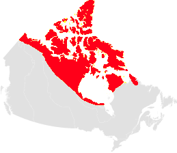
The permafrost region covers the northern part of Canada exhibiting temperatures in rock or soil that remain at or below 0°C through the summer. Water in pores and fractures under this condition is normally frozen. This region includes all of the artic area of Canada and parts of Nunavut, the Northwest Territories, Yukon, Manitoba, Ontario, Quebec, and Labrador north of the tree line (Fig. Map-1). The southern margin is irregular as secondary features such as the type of vegetation cover or snow depth begin to control where permafrost occurs because of the influence on heat exchange exerted by these factors. Consequently, in the southern Yukon, upper Mackenzie valley, the northern prairie provinces and northern Quebec, permafrost will occur further south in particular settings such as peat bogs or on north-facing slopes.
The climate of the permafrost region is dominated by continental and polar maritime (influenced by the ocean) subtypes. The main constant is that the climate is affected by the extreme solar radiation conditions of high latitudes. The mean annual temperature ranges from -20°C on Ellesmere Island to -6°C along the southern boundary. Mean annual precipitation varies from 100 mm in the north to 600 mm in the southeast. The low precipitation of the central arctic is the lowest in Canada and this area is often referred to as a polar desert. The southern permafrost region is characterized by dwarf shrubs that decrease in size and composition to the north where vegetation becomes dominated by herb and lichen.
The Permafrost region covers the northern part of the rugged terrain of the Canadian Shield and gently undulating regions of the Mackenzie valley and Arctic Archipelago and mountainous areas. Mountainous terrain in the northern Cordillera is important because of the possible restriction of permafrost to lower elevations where atmospheric inversions in winter lower the mean annual air temperature.
The Permafrost region contains a diverse array of geological elements that include igneous and metamorphic rocks of the Canadian Shield, sub horizontal sedimentary rocks of the central Arctic and folded and faulted sedimentary rocks of the northwest Arctic Islands. Evaporites are found in the subsurface both in the Mackenzie valley and central to northern Arctic Islands. Surficial sediment consists of regional till sheets, localized glaciolacustrine and glaciomarine deposits, and glaciofluvial deposits. In the Yukon large valleys are filled with course glacial outwash and finer lacustrine sediment.
