| From NRCan wiki |
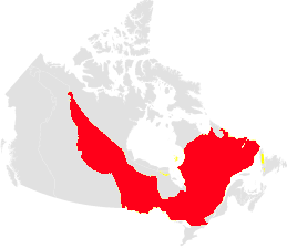
The Canadian Shield is the largest physiographic region in Canada with 32% of the land (1.8 million km2) and 10% of its fresh water. It is a vast region that extends from the Northwest Territories to Labrador, including northern Saskatchewan, and much of Manitoba, Ontario, and Québec. The region has low population density with population centred in areas of mining and pulp and paper activity. The Shield is rich with timber, mineral and natural resources that attract recreational use.
The Shield region climate is continental with long cold winters and short warm summers. Regions bordering large water bodies tend to be warmer in winter and cooler in summer with the exception of those water bodies that are ice covered during the winter. Precipitation is low to moderate and ranges from ~400 mm in the west to 1 000 mm in the east. Precipitation and temperature both decrease from south to north. Forests of spruce, balsam fir and pine predominate while broadleaf trees occur in more southern areas. Open, permafrost-stunted Black spruce forest occurs in the northern terrains
The regional landscape consists of a series of peneplain uplands between ~200-1000 m asl, having relief of 50-100 m. Greater relief of 150-300 m occurs along river valleys incised into uplands and plateaus. A series of large lakes occur along the southern boarder of the Shield with sedimentary basins (e.g. Great Lakes, Great Slave Lake)
The Shield is composed of Precambrian igneous, metamorphic and meta-sedimentary crystalline rocks formed during several phases of mountain building and other tectonic events (Fig. V-3). Subdivided into geological provinces according to deformation style and age, each geological province comprises banded or foliated rock that have been metamorphosed and deformed to various degrees as greenstone-sediment terrains and adjacent gneissic belts. These have been intruded by granitic rocks and regional dyke systems. Much of the area has a discontinuous cover of thin glacial sediment. Thicker surficial deposits occur in areas of glacial landforms such as drumlins, eskers and moraines. Extensive glacilacustrine deposits occur in parts of Quebec, Ontario and Manitoba and form extensive clay basins with underlying sand and gravel deposits.
Ubiquitous crystalline rocks are characterized by consistently low primary porosity, permeability and variable fracture patterns, and generally have water low yields (Fig. V-3). Fracture zones are found to yield potable water to depths of ~100 m, and at greater depths the groundwater becomes progressively saline, reducing, and old. High total dissolved solids of 50 -100 g/L occur in the sparsely fractured deeper rocks. Elevated heads in Shield rocks remain due to surface loading from the Laurentide Ice Sheet. Surficial sediment aquifers are important, particularly high yield glacifluvial aquifers that provide most of the municipal drinking water supply from groundwater. Agricultural areas on the shield, in glacilacustrine clay basins, generally rely on surficial aquifers. Recharge and discharge patterns are likely localized by fracture patterns. The modest undulating relief on the Shield provides low driving force for slow groundwater movement and reduced mixing at depth. Water quality can be compromised in bedrock fracture systems due to bedrock mineralization, particularly due to uranium and radon gas.